
-
{{ item.quantity }}
MELWAY HISTORY
How it all began
Merv Godfrey was the originating designer and cartographer of the Melway Street Directory. He trained as a survey draughtsman with the Victorian Lands Department. He served with the RAAF as a radio operator during WW2. Following the war he was employed with the SECV and became involved with various tourist maps during his “out of hours” time. Merv was one of the founding members of the Institute of Cartographers and served as honorary treasurer for ten years. He holds the office of Fellow Member in recognition of his contribution to the Institute and cartographic achievements.
His involvement with Ray Harrison, a publisher, in the mid 1950′s gave him the opportunity to produce the Olympic Games map of Melbourne in 1956. He also was involved with many other tourist, airline and oil company maps.
During the 1950′s Melbourne had several street directories, Morgans, Collins, Robinsons & Universal. Merv could see the shortcomings of these directories and proposed to Ray Harrison the possibility of producing and printing a Melbourne Street Directory. The concept was to produce a multi – coloured high quality directory printed on a good quality paper. Around 1960 Merv met Iven Mackay, who was also interested in the same project, he eventually became Merv’s partner as Ray Harrison died before the project had progressed very far. Merv resigned from the SECV in 1961. They began in earnest the task of producing the new directory. Merv, from his home studio which remained his office until 1985, assumed the role of creating his vision of designing and drawing the highly accurate multi coloured maps. Iven took these maps and drove many thousands of miles in a secondhand old Morris Minor field checking every road and detail.
Iven Mackay passed away in May 1989, 23 years after the first edition was released, and the Godfrey family assumed full ownership of the business.
The Melway philosophy has been to create a high quality product, while keeping operating costs low, resulting in competitive pricing. With this philosophy Melway has been one of the true “cottage industries”, as the map production mainly took place at Merv’s studio with family members helping out.
All the maps for the first edition Melway were pen and ink drawn, larger than final size. All typesetting was hand composed and printed on a hand operated letterpress machine in Merv’s garage. Various members of Merv’s family were press ganged into typesetting (Merv’s wife Barbara) and the printing – there were many thousands of names to be set for the maps. Once the maps were drawn they then had to be photographically reduced to final size. A simple camera was built specifically for this one task. As completion of the mapping task grew near, the hours correspondingly grew greater – often into the early hours.
Early in 1966 all maps were completed and ready for printing. P.C. Grosser Pty. Ltd. of Moorabbin were the printers used for the first five editions. Melway hit the streets in May 1966 at a retail price of $2.50, nearly twice the price of its nearest competition. Melway’s first publicity was by Graham Kennedy on IMT’s New Products. Many sceptics said it would never sell because of the price difference. However, it not only survived but has become the most comprehensive directory in the world. It is more than a street directory and there is no other name to describe it but it is a “Melway”.
Merv together with his partner began the task of looking to the second edition and realised they had made a rod for their own backs in keeping pace with a growing Melbourne and updating every map on an annual program (In 26 years 22 editions were produced). It was during this second edition that Merv noticed the talents of a young cartographer working for the printer P.C. Grosser. He invited him to help with the Melway cartographic work which Merv’s partner would collect from various sources and hand over to Merv for upgrading.
The second edition saw the change over from pen and ink drawing to the then still relatively new technique of scribing and cut and peel masking. These had time saving advantages as it allowed the cartography to be carried out at map size. It also saw the introduction of phototypesetting and photolitho film reproduction for the second and subsequent editions of Melway. To produce the film work for the second edition, Merv converted a cupboard in his studio into a darkroom. Conditions were cramped but the results were to Melway standards. Later a darkroom was added to his studio. In the early years all map film was hand developed. In 1977 Melway bought its first film processor which replaced hand developing. In 1993 PC’s were used to generate the indexes in-house. In 2000 the Melway maps were all generated by computers. In 2001 the film processor was removed and maps and indexes were passed electronically to the printers. Melway first occupied premises in Milton Parade, Malvern in 1967 and moved to larger premises at 25 High Street, Glen Iris in 1972. In 1978 Melway moved to 19 – 21 High Street, Glen Iris. In November 2002 Melway moved to its new premises at 32 Ricketts Road, Mount Waverley, 3149
The company still employs the original philosophies:- ‘to produce a high quality and up to date directory at an affordable cost, and to be far more than just a street directory’.
Melway – Years of excellence
The First Edition of Melway Street Directory was published in 1966 after having taken five years to compile. After a very short time, Melway had firmly established itself as Melbourne’s number one Street Directory and quickly became a household name.
The name Melway was originated by the publishers from the “Mel” of Melbourne and “Way” from find your way in Melbourne.
When Melbournians are looking for a street they don’t just refer to a street directory, they “look it up in the Melway”.
Melway is the most advanced, accurate, up to date and comprehensive street directory produced anywhere in the world and its enormous success is due to the dedication and innovation of the Melway organisation.
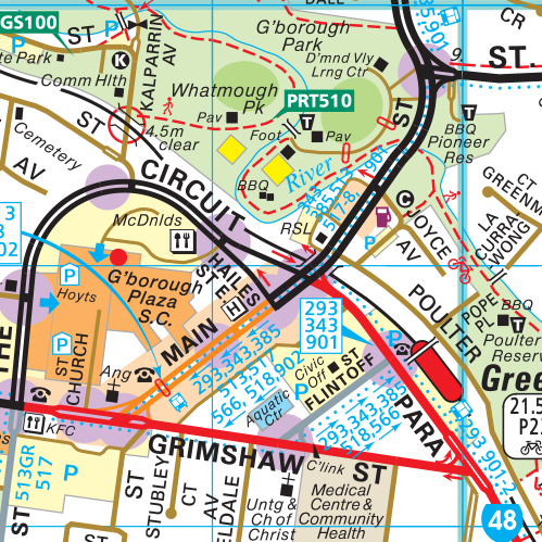
The Melway maps not only show in colour the total Melbourne road network but also include a wealth of additional information such as tram and bus routes, schools, shops, churches, Police Stations, traffic lights, public telephones and hospitals just to name a few.
Melway is used by the Police, Ambulance, Fire Brigade and all Government Departments as well as the Real Estate, Taxi and Bus Industries. In radio, television and press advertising the Melway Grid references are now widely used by companies and organisations to assist clients and customers locating their premises.
Each new edition of Melway is completely updated and revised and additional pages of maps and information are included. Melway is wholly owned and produced in Australia.